
Strategic landscape restoration for resilience in Chad
Project Overview
Chad is ranked among the most climate-vulnerable countries globally, experiencing severe land degradation that is estimated to cost the country $920 million over the next 25 years—equivalent to 7.5% of its GDP. With over 85% of the population dependent on agriculture and livestock for their livelihoods, the degradation of croplands, pastures, and forests directly threatens food security and economic stability. Recognizing that reactive approaches to address these challenges are insufficient, The World Bank is working with the Government of Chad to develop a comprehensive, data-driven strategy for sustainable land management.
To support these efforts, NatCap Insights created a strategic framework that identifies where restoration investments can deliver the greatest returns across Chad's diverse landscapes—from the Saharan north to the more vegetated Sudanese zone in the south. This analysis combines climate risk assessment, land degradation modeling, and ecosystem services valuation to pinpoint priority areas where targeted interventions can reverse environmental decline, enhance resilience, and improve rural livelihoods.
Results from this collaborative study confirmed that restoration of degrading landscapes in Chad is economically viable—with cost:benefit ratios of 3 to 1—and so it makes financial, ecological, and social sense to implement restoration actions sooner rather than later.
What We Did to Help
-
We analyzed climate change projections through 2050 and evaluated 20 years of satellite vegetation data to map where climate risks and land degradation intersect most severely. Our analysis revealed that central Chad's Sahelian belt faces the greatest climate risk, while southern agricultural provinces experience the most severe land degradation due to population pressures and unsustainable land use.
-
Using the InVEST® modeling toolkit and custom frameworks, we quantified how ongoing land degradation affects critical ecosystem services—carbon storage, erosion control, water regulation, and grassland productivity. We projected that among other impacts, carbon sequestration could decline by nearly 44 tons per hectare in some areas, while flood mitigation capacity could drop by 43 cubic meters per hectare annually, if actions are not taken today.
-
Our spatial optimization analysis identified nearly one million hectares of degraded land where restoration would yield the greatest ecological and economic benefits. The amount of land to restore in each land cover type (forest, shrublands, grasslands, croplands, and wetlands) was estimated to maximize the benefit-cost ratio (BCR) while aligning with Chad’s pledge under the African Forest Landscape Restoration Initiative (AFR100) of the Africa Great Green Wall Initiative. We then prioritized where best to restoration actions based on their potential to reduce land degradation, improve water regulation and quality, mitigate climate change risks, improve carbon storage, and increase forage biomass.
-
We performed a comprehensive cost-benefit analysis demonstrating that on average, every dollar invested in restoration yields returns of $3.3, with an internal rate of return between 28% and 34%. The analysis showed that strategic restoration of 983,000 hectares would require $22 million annually but generate $83 million in benefits per year through 2050.
What We Created
Maps of climate and land degradation vulnerability
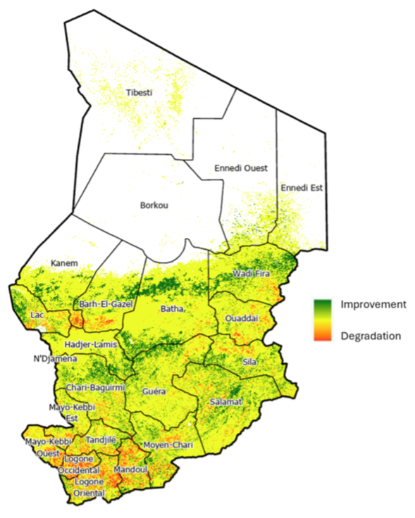
Land degradation patterns in Chad | © The World Bank
We developed detailed climate risk maps showing that the greatest vulnerability occurs in the Sahelian belt, particularly in central Chad, with risks primarily concentrated during the rainy season (June through November). This area faces high temperatures, extreme precipitation variability, and increased flooding risk.
Our land degradation assessment projected changes between 2021 and 2050, revealing that croplands in the south are most vulnerable to land degradation pressures, while some portions of the country show improving vegetation conditions, indicating complex dynamics between climatic shifts and human-driven land use changes.
In this map, areas in red are at the highest risk of land degradation based on 20-year vegetation and areas in green have experienced some improvement.
Targeted maps of restoration opportunities
We combined high-resolution analysis of restoration potential to produce province-level summaries showing the optimal locations for five types of restoration interventions. These maps allow decision makers in the country and their World Bank partners to plan and implement restoration programs within the local context of each region.

Area targeted for land restoration (in hectares) by type of intervention and by province | © The World Bank
Projections of ecosystem service benefits
Our analysis revealed distinct spatial patterns in restoration benefits: carbon sequestration potential is highest in central and eastern regions such as Bahr-El-Gazel, Kanem, Wadi Fira, and Ouaddaï, while highly arid regions are limited in their carbon potential. Areas that have the highest levels of erosion currently, such as Kanem and N’Djamena, would benefit most from restoration strategies that stabilize soils. Traditionally pastoralist regions including Bahr-El-Gazel, Kanem, and Ouaddaï stand to benefit most from pasture and rangeland restoration, which act to increase fodder and forage production. Flood mitigation improvements are most significant in southern provinces like Logone Occidental, which are located along major river basins.
Investment framework
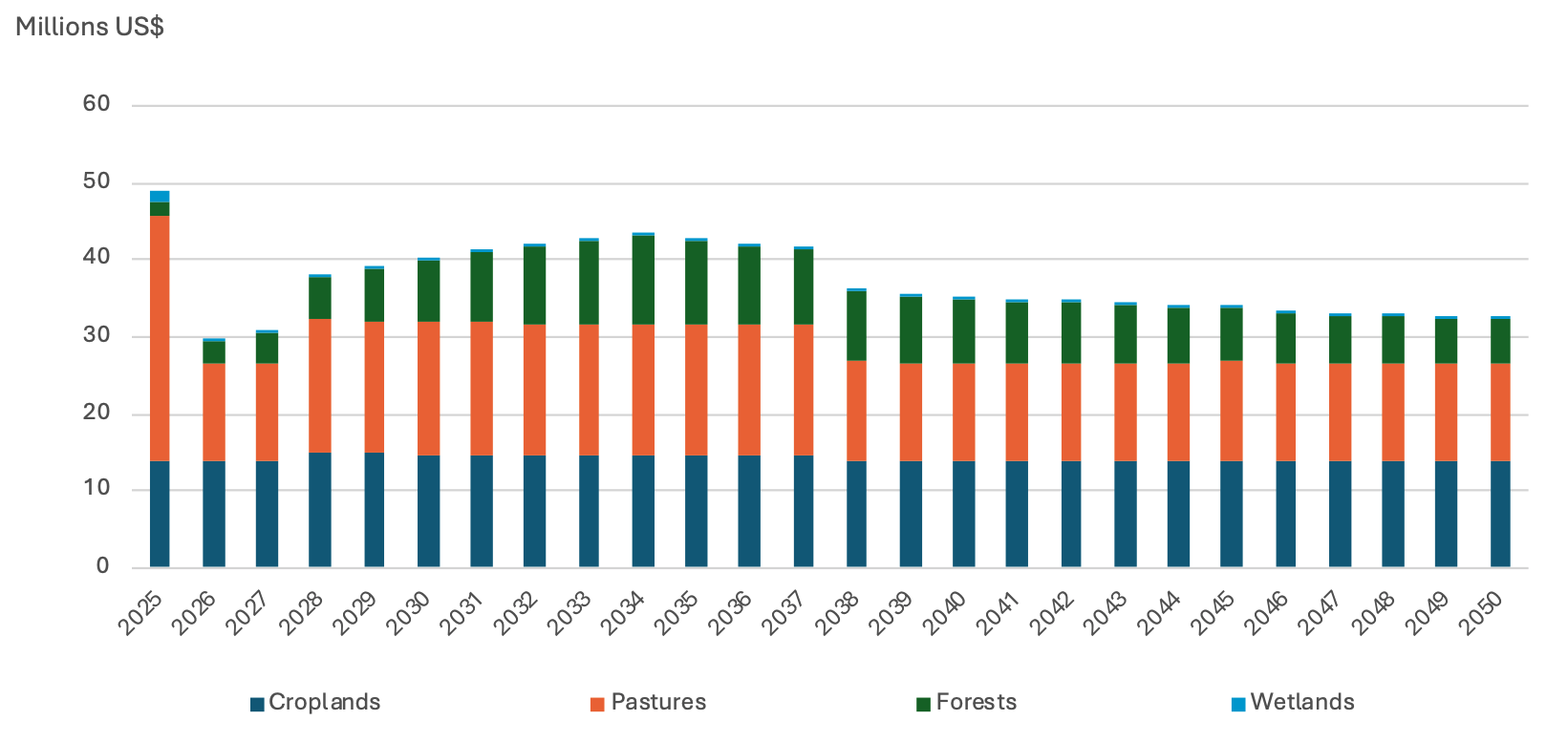
Annual investment plan for restoration action on 0.98 million hectares of degraded land in Chad
We designed a comprehensive restoration strategy specifying the optimal interventions for each land cover type: conservation agriculture and crop diversification for croplands; rotational grazing and silvo-pastoral systems for pastures; conservation and vegetation management, agroforestry, and reforestation for forests and shrublands; and rehabilitation for wetlands. The framework includes a detailed implementation timeline showing that 80% of total restoration investments ($457 million of $570 million) should be concentrated in the first 15 years when intensive actions are most needed.
Project Impact
Our analysis provided clear guidance on where different restoration approaches will deliver maximum impact—from reforestation in the central and southern provinces to shrubland restoration in eastern Chad and grassland rehabilitation in western provinces. Further, strategic restoration actions in Chad are projected to generate nearly 4,000 new long-term jobs directly, with an additional 6,000 jobs created in upstream and downstream value chains. Together, these employment opportunities will support the livelihoods of nearly 59,000 people, and women are expected to receive a significant share of these benefits since they make up most of the workforce in agriculture, animal husbandry, and forestry.
Restoration actions also go a long way towards offsetting the country’s emissions from land use and forestry, reducing greenhouse gas emissions by over 0.25 million tons of CO₂e annually from 2025 to 2050, with emissions reduction potential increasing over time as land productivity improves.
Our findings are informing upcoming national policy initiatives, such as Chad's National Land Use Plan and National Development Plan, and foster connections between ecosystem preservation, food security, and sustainable value chain development. By demonstrating that the economic returns on restoration far exceed the costs, our work provides policy-makers in Chad with compelling evidence that strategic environmental investments are not just ecologically necessary but economically viable.